Showing posts with label Volcano. Show all posts

Friday, August 16, 2013

Mt. Rainier Climb 7/4/2013 - 7/7/2013


The weather is good, the conditions are good, we have decent amount of time on hands. A perfect combination of elements for our Mt. Rainier attempt. This is the second time we are giving it a try. Two years ago we had perfect conditions while climbing the DC route; however one member of our 5 man rope team got sick and another felt completely exhausted when we reached elevation of 12,700 ft and for the safety of the entire group we decided to abandon the expedition and return to base camp.


This time we work with much smaller team. Dave and I leave Seattle on the Thursday afternoon, and drive to White River Campground. From there we hike to Glacier Basin where we meet with Darren who arrived first thing in the morning to secure our permits.


We spend the first night at Glacier Basin Camp. We do not see or hear the bear who kept campers company the night before, and enjoyed a good night sleep.


From Glacier Basin the path gets steeper. We climb up Inter Glacier, which is still in good shape with only one big crevasse opened and several smaller ones on the sides. Many people cruise the slope without roping, we choose to rope up both for safety and rope travel practice.


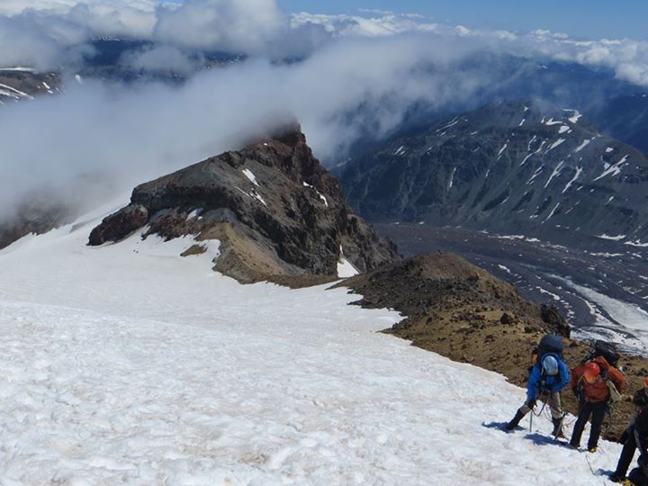
After learning the traditional traverse onto Emmons Glacier is exposed and not easy going, we opt for the alternative and head few feet past Camp Curtis from where an easy short scramble connects us with the path leading to Camp Shurman. The camp is now just a short distance away. It is nice to arrive early enough to have time to prepare for the climb, enjoy dinner and still catch few hours of sleep.

Midnight comes up fast, quick breakfast, and off we are on our way to the top of Mt. Rainier. The route is like a highway, we see beams of headlamps ahead of us and many follow.


To our liking, the route is rather straightforward. Several climbers we met mentioned it was much more crevassed than it usually is at this time of the year but we only end up climbing over one crevasse. Well, there is little bit of jumping involved too but otherwise we find the route in a good shape.

The summit is completely windless when we arrive, later a slight breeze picks up. It is cold up there but not the miserable kind when the frost bites you no matter how many layers you have on. Keeping pleasantly warm in our down jackets, we enjoy the 360 degree views. One party camps in the summit area. They are little bit off the summit so we do not have a chance to talk to them. Sunrise must be nice from here. Carrying overnight pack all the way up no so much.


With the nice firm snow at the top the descent, at first, goes much smoother than we expect.  It becomes more tiring once we reach softer snow and have to be careful about slipping. The sun is at full force at that time, the heat is exhausting.


It is nice to have one more night at Shurman. It would be brutal, long day, if we tried to walk out today.  Instead we chat with the ranger and his wife for a while and then decide to take a little nap - that lasts until 7:00 a.m the next morning.


On our way out we meet several groups equipped for a summit attempt. If the good weather persists many more will come and seek the challenge of Rainier. For us this quest is over but  the summer is just starting and plenty of other destinations await.


Friday, June 1, 2012

Island Peak - 144 Days to Departure - Mt. Hood


The highest peak in Oregon, Mt. Hood was on our list for about a year. We missed the opportunity to climb it last season, and were keeping a close eye on how this year is unraveling, so when the reports suggested good climbing conditions and weather looked awesome for the whole weekend and beyond, it was a GO.


The long drive to Timberline Lodge was highlighted by a brief lunch stop in Portland during which we also visited the famous Powell’s bookstore, and strolled through a small food market in a hope to catch the Czech stand but they were not there.

The forecast did not lie; the sky was clear blue and temperature in high 70’s. With the Jeeps’ top off we cruised through small communities of Rhododendron and Government Camp, from where we turned to the winding road up to the trailhead.


After registering for the climb and a brief visit of the lodge, we still had time on our hands, so off we were back to Government Camp for an early dinner and several hours of rest at local Best Western.

 The stars were out and moon shined bright when we once again stood at the trailhead at a wee morning hour – just little bit past midnight. The first part of the route was a non technical slog taking us to the top of the ski lift. The terrain was uneven, crossed by multiple sets of frozen footsteps and CAT tracks here, making progress slower than anticipated.


From the top of the Palmer's lift, the route got steeper but still led on a non technical terrain. Here, little above 9000 feet, my body started reacting to the altitude. I felt sluggish, not short of breath, just little nauseated and not quite motivated to make another step.

The avalanche forecast was not good for today. We knew our chances of summiting more or less laid in Mother Nature's hands, and not feeling my best, I set a goal for myself to make it to the Hogsbacks, from avalanche perspective the safe part of the route, and I was quite happy to call it a day there. Yet then the sun started to rise... and we found ourselves surrounded by tall walls covered in white frosty coating reflecting the colors of the rising day, several camp sites tucked in the few wind sheltered areas along the route, and finally the famous Hogsback itself. The scenery was truly spectacular, feeding my eyes and mind with much needed fuel, and after a brief stop to snack and assess the conditions (the route turned out to be in a great shape), I found myself having plenty of energy to continue further so we geared up and off we were for the push to the summit via the Old Chute Route.


The sound of ice crystals constantly shifting down the slope accompanied our steps, at one point their flow was strong enough to cover the route, swallowing our feet in the appr. 5 inches of ice shatters. Then the last uphill came, luckily the group ahead of us kicked decent steps in the steep slope, and we took this staircase directly to the heavenly views of the summit ridge. From there it was just a matter of few minutes to cross to the very top of the mountain where, just as expected, gust slapped our faces, chasing us down after only few minutes and several quick photos.


Date: 5/13/2012
RT: 7 miles
El: Gain: 5200 ft