Day 1 - September 30, 2013
Jeseníky, mountain range in the uppermost part of Northern Moravia, home of the highest peaks of the region. It is also known for its kosodřevina (Mountain Pine), several areas of rašeliniště (peat bog), and in the winter skiers come to enjoy both downhill and cross country skiing.

During the summer months tourism is popular here. Visitors come in hundreds. Areas like Ovčárna, Praděd or Švýcárna where the trails are generally easy are overcrowded, but even the harder routes see their fair share of traffic. For those seeking more solitude, fall might be more enjoyable season to visit. The days are colder and often windy but the displays of yellow and red autumn tones are worth the extra layer.
Our trip starts in Sobotín, one of the bigger villages around, where we park our car and follow the blue trail towards junction Na Skřítku, the official starting point of the Jeseníky Traverse. Our estimate of around 4 miles is way off, with all its twists and turns the stage is 7.5 km long. It's an easy going trail, gently climbing through forests where the upcoming fall colors the foliage.

Arriving at the junction at around 13:00, 2 hours after we left Sobotín. We stop at a local motorest Skřítek (dwarf) for lunch, it's not the best food, but it's all right for quick energy replenishment here in the mountains. At 13:36 we are back on a trail.
After the initial shock of finding out the half point between here and our destination is still 11 kilometers far we realize the route we are suppose to take is marked green, not yellow and will get us to the same spot in 6 kilometers. And green we follow.

Arriving at Ztracené Kameny (Lost Rocks) at 14:45 we take in first views of the surrounding forests and mountains. Comparing to the mountain ranges we are hiking in Washington State, Jeseníky with its highest point in just little over 1,400 meters could be called hills, but beautiful hills I have to say.
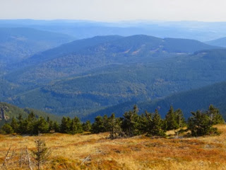
Jeseníky are known for their ridge runs. Not much vegetation grow in the higher elevations, except for a short pine like bush called kosodřevina or kleč (dwarf mountain pine) and thanks to the lack of tall trees, the ridges usually offer great views of the mountains nearby and into the valleys bellow where villages can be pointed out.

Soon after Jelení Studánka (Deer's well) junction we hit our first ridge. We are now 6 km away from our destination. Kosodřevina lines the slope to our right, and behind the bushes we see down into the valley. Meadow runs along the left side of the trail. Wildflowers, and they are plentiful during spring and summer, are gone, the grass carries colors of fall. It is a beautiful walk with minimal elevation gain, and if it wasn't for time pressing us, and strong wind blasting into our faces, I would suggest a break here to enjoy the views among which are those of Praděd, the highest mountain of the range which we'll hike tomorrow.

Hotel Figura where we are staying at looks deserted when we arrive at 17:15 after completing 19.5 kilometers. I try to call phone number posted on the door, nobody picks up. The wind is howling, we are freezing, contemplating our alternatives. Neighboring hotel Sabinka is also dark and shows no signs of life. We walk to Ovčárna, the most famous hotel in the area. They are fully booked but offer to call our hotel again, with better luck, and 10 minutes later we open the door to our warm room.

We return to Ovčárna for dinner of kynuté knedlíky (fruit dumplings), řízek (schnitzel) and some winter warmer drinks from which warm egg nog with rum is our favorite.
Day 2 - October 1, 2013
9:30 is not the earliest start but we only have 15 kilometers ahead of us, many of them downhill. Our day starts on paved road leading all the way to the top of Praděd. It's a walk rather then a hike. In the past there was an option to take a trail on the other side of the mountain but now any pass other then the road is blocked and a sign asking visitors to stay only on marked trails is posted.
If it wasn't for the fact Praděd is the highest mountain of the range and whole Moravia, and it is possible to visit the platform 73 meters up the tower for views, I would be happy to skip this mountain. Especially on a day when cold wind blasts around in a speed of 20 kph.

The next part of the route slopes downhill. The drop is gentle, and still on paved road but at least we are between trees now, for most part out of the wind. Švýcárna, an old salaš (residence of shepherds) welcomes us at 12:49. Today there is a tourist cottage here where hikers can warm up with a cup of tea or a bowl of soup. We have completed 7 km of today's stage, with only 8 more to gone, we also sit down for a warm lunch.

Following recommendation from an article I read about the traverse, we leave red trail here and continue on blue which should take us through more pristine scenery. We hike through forest, with some nice views. It is a pretty route but on a gravel path, too man made to our liking. When an opportunity arises to switch routes for more trail like path we take it. This pass is much more fun, muddier, trickier with roots and rocks in the way, much more our style. It takes us to yet another junction. Here we decide to reconnect with the red trail. We find it after a short climb. The trail runs the ridge and contrary to the description which called it "the most boring part of the traverse" we enjoy the open, exposed to wind trail with views and several short sections of steep climbing.

Eventually we start our final descend to Červenohorské Sedlo (Red Mountain Saddle) where we stay tonight. There are two choices here, the cottage and the hotel. We have accomodation booked at the cottage which is significantly cheaper but after seeing the room which consists of five old squeaky beds plus several pieces of very aged furniture from which parts are peeling, and dirty shower at the hall, we make a decision to pay extra for a room at the hotel, and the decision definitely pays off.

Day 3 - October 2, 2013
Well rested we come down for breakfast which is included in the price of our room. The food is coming and coming. Variety of bread and toppings - cheese, jam, Nutella, butter - tray loaded with fruit, hot item - our choice is from eggs, wiener sausage and smoked sausage, and the hot item also comes with a large plate of beans. One nearly needs siesta after finishing.

The energy is needed. Today's stage is not only suppose to be most scenic, but also most difficult with a climb of 3 mountains along the way. It's around 10:00 when we start hiking. Forecast promised a sunny day but the layer of clouds above our heads tell a different story. It's cold, and somewhat windy, and even though we are heading uphill (very gently), we put another layer on.

After a short side trip to Sněhová Kotlina (Snow Basin), place where frequent avalanche activity can be seen, and a short off trail scramble we reconnect with our route; however alternate trail comes shortly, one that leads to the top of Červená Hora (Red Mountain). This trail takes from gravel road to a dirt path, heading uphill among forest of kosodřevina. It's a pleasant climb, not really steep with more and more views bellow us. Today they are obscured by clouds, and only occasionally we see a village or two, but the views we lack bellow are more than generously replaced by beautiful scenes here in the heights. Clouds rise around us, occasionally letting sun rays through. These sun breaks don't last more than 15 - 20 seconds but during the short time foliage of ever present blueberry bushes turn crimson red, and straws of grass bath in golden glow.

Summit of Červená Hora consist of a small rock formation. While the view down into the valley is still cloudy, we can see a decent distance to the opposite direction where hills stretch and yellow foliage of leafy trees remind us summer is definitely over.

The temperature is just slightly above freezing, and once we start climbing towards the second mountain of the day Keprník, frost decorates the shrubs and grasses, beautiful white touch added to the mix of fall colors. At 13:15 we reach the summit, rim ice grows from the sign post, and as far as we can see grasses are wintry white.

Same scenery awaits us atop Šerák, our last summit and westernmost mountain in Hrubý Jeseník. Gladly we slip inside the cottage at the summit to warm up with a cup of tea. Chata Jiřího na Šeráku was built in 1888, burned down in 1893, and was reconstructed the same year. Today the rooms look much different, cozy and warm with modern showers and comfortable beds. This is where we stay tonight.

People hike Šerák Mountain to enjoy views. We are not granted any, the weather is getting progressively worse and by 17:00 the clouds around the cottage are so thick we can hardly see more than 15 away. So instead of views we enjoy glass of mulled wine, best we tasted along the route, hoping the weather will clear during the night.

Day 4 - October 3, 2013
It's around 6:00 a.m. when I wake up into the colors of a beautiful sunrise. The sky is clear, there is no trace of the yesterday overcast. View from our room down in the valley is incredible, excited for the sunny day we start our hike shortly after breakfast.

The trail leads us downhill and it is so far the most difficult trail we experienced here. Full of roots and steep natural steps our knees get a haul, luckily the path is dry through the forest, and where there is ice in the open areas, the trail easies on its steepness and allows us to get around.
Obří Skály (Giant Rocks) are the first stop on our way. It's warm and the rocks lure us to little bit of scrambling.

Back afoot the trail connects with gravel road but dreaded road slog does not materialize. Soon we see a narrow path by a tree with a trail sign. We take it and before long we find ourselves sliding down a slippery hillside. At this point it's obvious this is not part of the regular route, our boots are dipping in the mud, green belays come handy. Our little adventure ends at a creek where we can clean our boots. Climbing up the opposite side is much easier and reconnects us with the trail.

Ramzová where we arrive around noon feels just like any other ski town during October, empty and shut down. Owners of most pensions are taking advantage of the couple month between seasons to finish repairs, even local pub is closed. Finding a refuge in the only open pension around we order garlic soup, it is a good honest soup made from scratch, with croutons, egg and cheese.

I'm leaving happy that after over 20 years I finally made it back to this picturesque mountain range, and I hope that next visit will come with much shorter time gap. There's still many more beautiful places to explore here.


