
When I first learned that I would have to switch my vacation from beginning of July to beginning of August due to some scheduling difficulties in our office, I frowned. Four more weeks of waiting for the much needed time off seemed agonizing at first but soon the smile returned to my face. That’s when I realized that those extra weeks will allow for more snow melt and will open a whole lot of new areas to go backpacking. The Wonderland Trail immediately came to mind.
Between learning more about the loop, supply shopping, and
trying to decide on a back-up plan should we not be able to obtain a permit,
the time flew and there we were on afternoon of August 3rd driving
South, little worried how things will turn out. Let’s admit it. The chances of
walking to Longmire Ranger Station on Friday afternoon securing a permit for
the Wonderland Trail starting on weekend during the peak season are not that
good.
Somehow, and I still find it hard to believe, the luck was
on our side. Within 10 minutes we had a permit in our hand for exactly the
route we wanted, except for Klepatchee Park Camp, which was the only one fully
booked for the night we wanted to stay so we settled for a longer day and a
stay at the next camp instead.
Starting from Mowich
Lake


The next morning we set out for the adventure. It was 8:22 a.m. when we left the trailhead,
and the sun was already beating down on Earth, bringing drops of sweat to our
foreheads even on the first downhill part of our route. The destination for the
day was Cataract Camp via Spray
Park
The trail soon took us to the beautiful stretch of Spray Park
In one of the meadows we spotted a smaller black bear. Not
bothered with out presence, he strolled to a creek to take few sips of water,
and then lay on a snow patch at the far side of the meadow and rested there,
cooling off, while we stretch our camera’s zoom to maximum to take a
semi-decent photo.

The landscape character changed as Seattle Park Spray
Park Mt.
Rainier
We spend considerable amount of time here. Dropping our
packs, and free of the weight we roamed towards Echo and Observation rocks with
views of Mt. Baker, Glacier Peak, and Mt Stuart behind our back, and that was
just to name a few. The day was clear and the views astonishing. Here we met
our friend Amanda who was exploring the area on a day hike trip, and ample of
other hikers and backpacker, many of whom we exchanged few words with.


When the sun dropped towards the horizon, it was time to
leave this breathtaking area behind, and drop down the valley to our first camp
– Cataract Valley

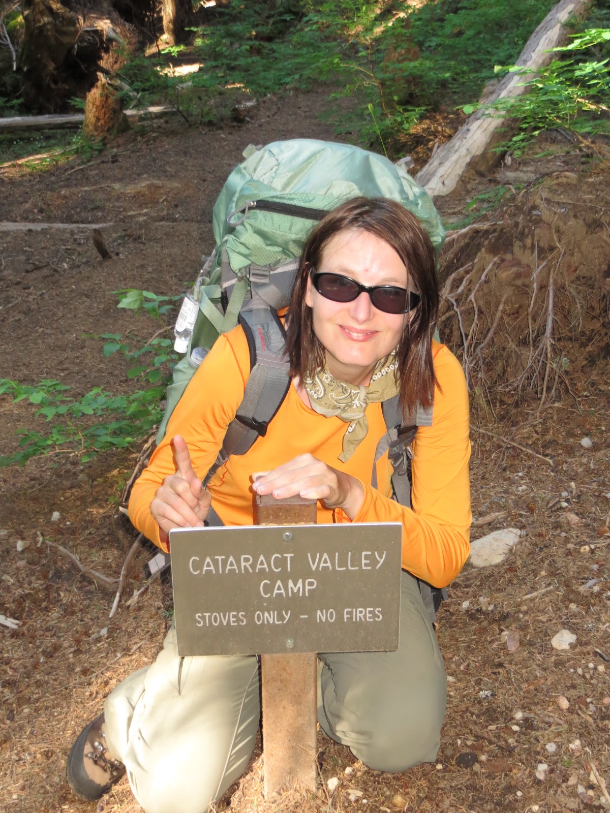
DAY 2, CATARACT
VALLEY MYSTIC LAKE
The morning sun woke us up at 6:30 a.m. , and it was surprisingly warm already. So warm
that even a downhill walk under a thick canopy of trees produced sweat. Various
berry bushes could be seen along the trail, but their fruit was far from being
ready for our consumption.
After an easy 1.6 miles the trail spitted us at an
intersection with Carbon River Camp. We took few minutes to check it out, as we
later did with all the other camps, and found it being a pleasant place,
located nearby a creek and a waterfall, with sites 1 and 3 being especially
nice.

From there it was not far to the first suspension bridge on
our route, followed by the first serious incline. More exposed the trail was,
and the sun baked relentlessly us all the way up. I haven’t felt more sluggish
in a long time, it’s amazing how quickly heat can effect one’s hiking
abilities. The views were of Carbon Glacier and stretched up the valley, topped
with a view of Rainier itself. There was an
interesting contrast between the dirty look of the glacier and the spotless
beauty of the volcano overlooking it.


At last, after 2.5 hours and 2 snake encounters the trail
eased up a little and led us through Morraine
Park
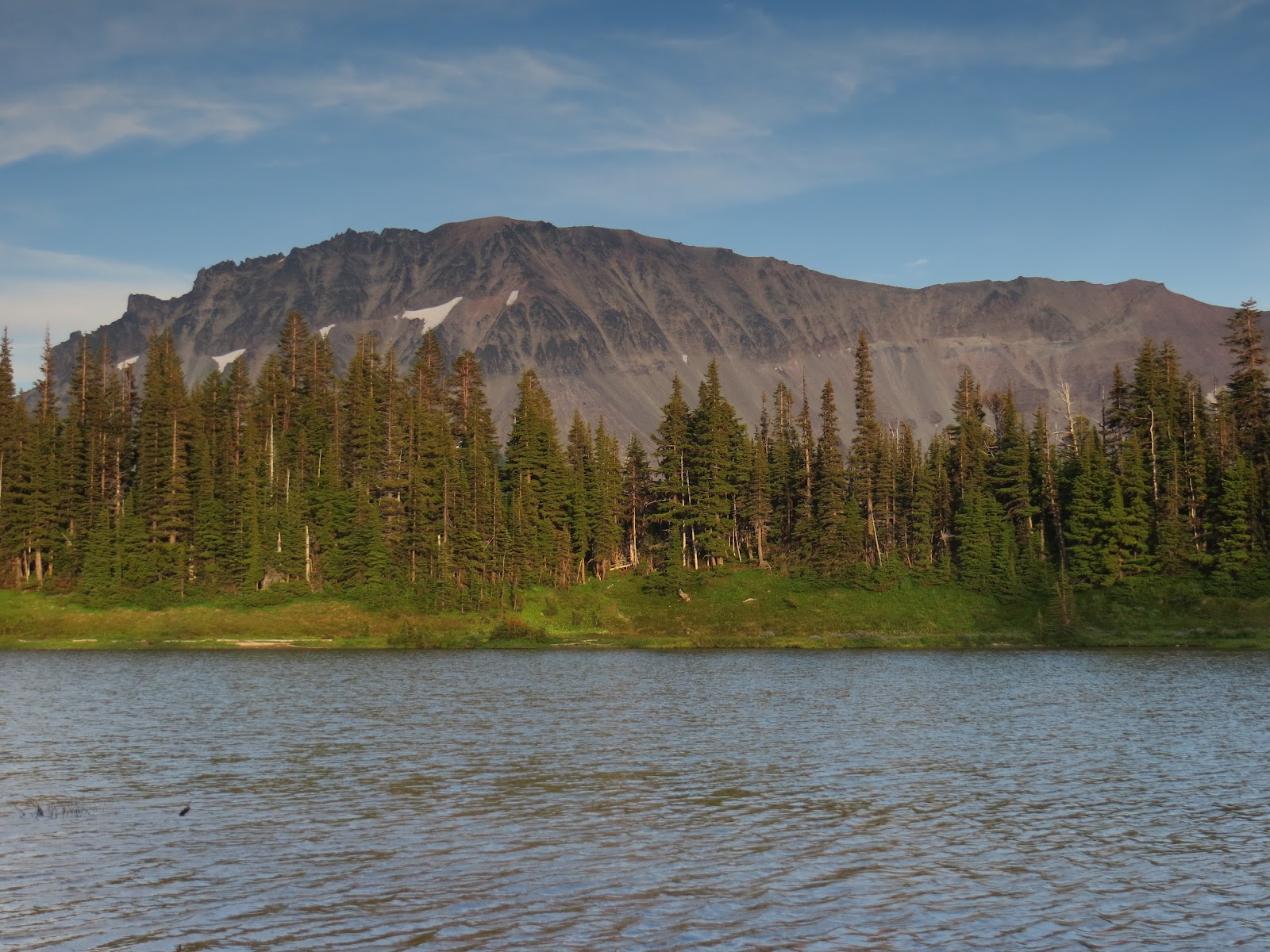
When we reached Mystic
Lake
0.4 miles separated us from the camp, and as we stepped
through a denser area, I turned to Dave to warn him of upcoming snow patch. His
interest seems to be laying somewhere behind me. I turned to see what caught
his attention, and froze half way in my turn as I found myself facing another
cinnamon bear. His proximity, barely 20 feet from us, made him the closest bear
I’ve ever been cautiously near to.
He looked at us, as if he was considering whether we would
make a worthy snack, then he moved, luckily the opposite direction, and before
I unfroze and reached for my camera, he was nearly gone in a dip behind a bush.
It was incredible to watch how animal of his size could vanish in such a short
time, making nearly no noise.

That evening we decided to have dinner by the lake, and as
fate would have it, on our way there, we met a ranger, who invited us up to the
patrol cabin where there was a view of Mt. Rainier

The mosquitoes were present in the area, and even higher up
from the lake, when several groups of backpackers gathered at the patrol
station, they swarmed and bit relentlessly. Here with a view of sunset colors
reflecting of Mt. Rainier, we met a
group of 4 backpackers from Florida, and a group of 3 ladies, all of whom we
had the pleasure to share the next two days of our journey with.
DAY 3, MYSTIC LAKE SUNRISE
Getting up early paid off. Not only we escaped the heat,
most of the morning was overcast, but we also got to Sunrise Camp first, and
though could be really picky about choosing our site. Only one had a view of
the lake, and that one won.
The terrain we covered included a downhill on a ridge, an
unabridged water crossing which under given conditions was not posing a problem
but should the water be little higher or faster, it could turn tricky, and a
long uphill in the shade of trees.


On our way we passed Granite Creek Camp which we found neat
but not overly exciting, tucked in the trees far away from any views.
The terrain opened shortly before we reached Skyscraper Pass
We reached the camp after a stroll down to Frozen Lake


After making ourselves at home, a trip to Sunrise was in order. We haven’t been away
from civilization for long, yet a craving for fresh fruit creped in. On the top
of fruit we ended up having a burger and an ice cream.
Sunrise Camp was really nice but it had 2 negatives. First,
potable water was not available on site, the nearest suitable water source we
found was 0.4 miles away, and second, there were incidents reported lately
involving the resident bear who bluffed charged several times, and was now
becoming a nuisance (very unlikely this was his fault. If I had hundreds of Sunrise visitors, many of
whom have no idea how to respect wildlife, chasing me for a pic every day, I’d
probably get grumpy too).

The group from Florida
left a bottle with fuel at their site, and upon return from Sunrise , they found out they had a visitor.
There was a hole in the corner of one of their tents, the bottle cap was bitten
off and so was the one from a water bottle. They were certain it was the bear
who caused the damage; however in my mind the evidence did not add up. A bear,
in my opinion, would use his claws to tear the tent open, and I can imagine the
small bottle of fuel would get crashed in his mouth. A beautiful 10 point stag
we found wandering through the camp after dusk was more likely the culprit.
DAY 4, SUNRISE
It happened that our camp site with a nice view, was not as
flat as it appeared, and most of the night we end up slipping off our pads, so
when we got up, we did not feel that rested.
Luckily the first part of our day was downhill on a soft
forested trail. It seemed to be a long downhill despite what the map had said. Finally,
after what seemed eternity, we arrived at White River Ranger Station and picked
up our cache. After short refreshment, we hit the trail again. Luckily it was
flat for next mile or so, giving our bodies an opportunity to adjust to the
increased weight.

We were happy to arrive at the intersection with Summerland
Trail. We hiked this part several times before, and knew it was a reasonably
easy hike….. that is with a daypack. Now weighted down, the trail seemed much
longer. Switchback after switchback, we
steadily gained elevation, hoping the creek we wanted to refill our water and
chill by was just behind the next corner, and many times the trail tricked us
into believing it must be right there just to reveal several more hundred feet
of uphill and yet another switchback.
Eventually the creek came, rushing down swiftly, carrying
light breeze that cooled us off. And as we were resting, down the trail came
Ingunn Markiewitz. What a nice surprise! After several minutes of catching up
and taking photos, she continued on her way back, and we resumed the climb,
taking our time to admire the blooming meadows, and views of Little Tahoma, hoping
to catch a glimpse of the Summerland Bear but we had no such luck.

When we arrived to the camp, surprisingly none of the other
groups were there yet. We found a site we liked, way back with a partial view
of a meadow, and after we settled in and did our daily chores (washing etc), we
wandered up the trail and spend hours watching marmots playing in the meadows
of Summerland.


DAY 5, SUMMERLAND TO NICKEL CREEK
With a long day ahead of us, longest so far, we decided to
have an early start but when we woke up the first time, everything was socked
in. Our site felt like an island in a never-ending sea of fog.
When we woke up the second time, the conditions seemed
better. Even though some clouds were coming in and out, the sky showed signs of
blue, and visibility around us improved dramatically.


As I was preparing myself to get out of my cozy sleeping
bag, a chipmunk run to a lupine nearby and started his breakfast. Quietly I
reached for my camera to capture the precious moment.
The views were spectacular all the way to Panhandle Gap. We
arrived there first, the group of three ladies were right behind us, and once
we were at the top, we saw Florida
group making their way up also. This was a part of the trip they were not super
comfortable about, not having much opportunity to play in snow, so we made sure
we kicked good steps for them, and left a sign where route finding could become
a problem.


The view from the top of the Panhandle Gap was the last view
we had for a while. The clouds rolled in, and were there to stay. Visibility
varied from poor to none. At one point, we were not quite sure if we are still
heading the right direction, and that was the only time we during the entire
trip we consulted the gps.


The views returned as we dropped below the cloud. We were
now on a ridge that led us down through beautiful meadows. Across the valley a
tall dark walls rose to the sky, a home to 16 waterfalls we counted from a
single vantage point. I’ve never been to this part of the park but right then I
knew that if I should pick my favorite part of the Wonderland Trail, it would
be hard to find competition for the stretch between Summerland and Indian Bar,
and I was very sorry we were not spending the night.


Once we fully descended the hill and arrived at the beginning
of Indian bar Meadow, raging river stood in the way of our progress. We could
see the shelter at the far side of the meadow and we knew we would somehow have
to cross the river. The cairn at the bank pointed out this was the crossing
point but something did not feel quite right. The river run too strong to be
crossed safely, and fed by all the waterfalls above, it did not seem to ease at
any point through the meadow.
After a few minutes of exploring we found a path through the
bushes that connected us back to the trail. It was not an obvious one and in
the past the trail likely led closer to the water; however that part seemed now
washed out, and impassable.


Once back on track we made for the shelter. At the very end
of the meadow, we found Indian Bar Camp, up in the hillside the sides were
laid, some with a view of the valley, a very peaceful camp, but the best site
was no doubt the group site which was located at the shelter.


We crossed the river on a bridge and enjoyed a lunch at the
shelter in a company of a couple from Monroe who started their trip just the
day before, they got lost in Panhandle
Gap, and never made it to Indian Bar where they were supposed to spend the
night. The night fell, and unable to proceed they pitched their tent on a
hillside. They did not dare to resume their trek until they saw people in the
morning and could follow them through the snow laden, foggy stretch of the Gap.
We never saw them during the reminder of our trip, and part of me wonders if
they perhaps decided this adventure was beyond their skills and abilities and
turned around.
Here in Indian Bar we also said our farewells to both of the
groups we befriended in last couple days, and from now on we were on our own
again. We climbed a steep hill, the last 900 feet of elevation gain we had to
conquer before being able to cruise down to our camp sites, and as we were
ascending, the views grew, and wildflower displays made them even more
spectacular.


It was a late day, we did not get in the camp until around 6:22 p.m. Soon after we rolled the
pads out and set up bivis, we stroke a conversation with two girls from next
lot. It was their last night, and the day before they run out of fuel. We could
spare a boil. Their faces lit with smile over the prospect of warm dinner. It’s
amazing how people became part of your journey and you part of theirs. Little
acts of kindness go a long way in the wilderness.
DAY 6, NICKEL CREEK –
PARADISE RIVER

We were now entering what is considered the least
interesting part of the loop, a long slog down and up with not many jaw
dropping views, too close to civilization, and probably the worst tread of the
whole loop – a narrow trail leading too close to a cliff to my liking with
parts washed out and tricky to cross.
Yet nature has the most amazing ways of letting one forget
about all the stress of everyday life and experience joy in the most unexpected
moments. A patch of wild strawberries caught my eye near Box Canyon
Once we were past Box Canyon and turned on the long uphill
towards Louise and Reflection lakes, snacks of salmonberries and blueberries grew
at various spots along the trail, initiating numerous stops and little bit of
scrambling.

The nearer to Reflection
Lake Louise
Lake
Paradise River Camp where we arrived somewhat early, was
inhabited by not very social group, so we retreated to our site and hid in our
sleeping bags as the evening was arriving cold, and read The Fellowship of the
Ring. It felt good to give our feet few hours of rest.

And while we were reading, a doe wandered through the sites
and after her a fox, it looked just like the grey Paradise
fox that is often seen by the road, visited with us. It run away quickly but
despite its briefness it was a very neat moment.
Not so nice of a moment was our realization that our
itinerary was not quite correct. Things started not to add up when we
calculated remaining places we will spend a night at, and it nearly made me
jump to realize we had a 9 night/10 day itinerary not our originally planned 8
night/9 days one. I have no clue how we ended up with the extra night, and if
it wasn’t for the fact that I already got away with 5 vacation weeks this year,
I would gladly take that extra day; however I knew under these circumstances I
could not afford not to be at work on Monday morning bright and early.
Quick check with the map, which camp could we try to switch
to make things work? In the end, the best solution was to simply skip the last
camp and opt for a long 15 mile day to walk out. Any other combination would at
this point only add up to already longer days, and would make us speed through
parts we really wanted to take some time to enjoy.
DAY 7, PARADISE
RIVER

Another re-supply day. A bucket of goodies awaited us in
Longmire, including cookies and a bottle of wine. We arrived there at a good
time, after a brief stop at Narada
Falls Golden
Lakes
After a snack of chips from local convenient store, we were
on our way back to the wilderness. We met a few dayhikers in the beginning but
their number declined as we got further up the slope. It was a nice uphill,
gently grade and a soft ground to pamper our feet.
We spend most of the day in the shade of trees, the only
view came while crossing Kautz Creek, a very nice one of the water ravaged
valley and of course Rainier topping it off.


It was another early day, arriving at Devil’s Dream Camp at only
2:22 p.m. Devil’s Dream
was rather suitable name for this shady, mosquito infested place. They swarmed
no matter what amount of bug spray we put on. We did not plan to linger, the
plan was to go visit Indian Henry’s Hunting Ground, eat dinner and watch sunset
there. We left without even setting bivys, and hurried up hill in a hope the
mosquito situation would be better in the open meadows.
Better it was, but not by much. Luckily a breeze would go by
once in a while chasing the nuisances away for a brief moment. Either way it
was much more pleasurable to be eaten by skeets in a colorful meadow with a
view Rainier reflecting in its tarns than in the middle of forest with no view
whatsoever.


It was a pleasant surprise to see Ranger Dave strolling
through the meadow towards the cabin. He recognized us also from few days
earlier at Mystic Lake, and immediately a long conversation sparked about
duties and responsibilities of backcountry ranger, his adventures including a
very recent one with a Klepatchee Park Bear, and of course destinations around
the park and other places.

DAY 8, DEVIL’S DREAM – NORTH PYUALLUP
It’s always nice to explore a new area, and this day was all
about it. We entered the part of the park we never been to, not on the
Wonderland Trail, neither any other hikes.

It was a long day – 14 miles – and the mosquitoes returned
with the first sign of daylight so needles to say we were happy to leave
Devil’s Dream very early in the morning. We waved at Ranger Dave as we passed
the patrol cabin and from there we were in completely new territory.

After an initial descend we arrived at the second suspension
bridge on route. I was little uneasy about it after the story Ranger Dave told
us about a man who was so scared of crossing it that he scrambled down and
tried to cross the raging river, unsuccessfully, there is a suspension bridge
for a reason there. I was relieved to see this bridge was higher that the one
over Carbon River


Right from the beginning the following uphill promised more
open terrain and views. It was a pretty walk (if you can call huffing and
puffing that) up between wildflowers, I have never seen so many tiger lilies in
one place, with blue sky above our heads. Nearing the top, we stepped into a
rugged terrain of rock. Western Anemone thrived here but not many other flowers
bloomed around. The trail was rocky and tough, our pace slowed down, but every
ache our feet felt was justified by the beauty of this area. Smaller ridges
nearby invited us for scrambling while across the deep valley the bare cliffs
of Mt. Rainier
The meadows and wildflowers returned atop Emerald Ridge and
here right in front of our eyes we have all the elements of nature’s wild
beauty. Unfortunately we could not linger long, the miles ahead of us were
pressing and we continued on the gravely trail, admiring the scenery,
speechless.


Andrew’s Lake was still
mostly frozen, and at that point an ice bath for our feet sounded great so we
stopped to rest briefly. The water was, well it was freezing and at some spots
it had the consistency of a slurpee. And it definitely worked.

Refreshed we made it to Klepatchee Camp. Immediately we knew
why this camp was so popular. Campsites with a view of Mt. Rainier


The North Pyuallup Camp was full when we arrived, except for
the group site. We knew for sure we did not have a group site so either people
who were suppose to stay there decided they liked the individual site better,
or somebody who did not have a permit for the camp took our spot.

It was upsetting in a way but in the end we won. The group
site was spacious, had it’s own water source nearby, and an open view of the
sky which on Perseoid Meteor Shower
Night was not a bad option, even though we were so tired that in the end we did
not enjoy the show that much.
DAY 9, NORTH PUYALLUP – MOWICH LAKE
It was hard to break camp that morning knowing this was the
last day of our adventure. We had a 15-mile day ahead of us, so we did not
procrastinate, and before the sun was fully up we were on our way, lucky to
scale the first uphill to Golden
Lakes

The area of Sunset
Park


What followed was the longest downhill I have ever
experienced. 6 miles to South Mowich Camp on a long never-ending switchbacks.
I’m sure the people heading the opposite direction appreciated them but heading
down we could definitely use more direct, faster route.
A short break at South Mowich Camp, and hurray, the last 4
mile up the hill back to Mowich
Lake

And then we were back. 93 miles later we stood at Mowich Lake
